How do autonomous vehicles work? They use sensors, maps, planning, control, and communication to drive more safely. This guide explains self-driving technology in simple terms for 10th-grade readers. It also covers LiDAR, radar, GPS limits,…
How Do Autonomous Vehicles Work? A Guide to Self-Driving Technology
Estimated reading time: 13 minutes
Autonomous cars sound futuristic, yet they follow clear steps today. Sensors watch roads, read signs, and spot moving objects constantly. Software turns those signals into decisions, then actions safely fast. Cameras, radar, LiDAR, maps, and wireless links all help together. Each part has limits, so the vehicle combines clues carefully. That mix improves safety, comfort, and traffic flow on roads. Still, engineers must solve weather, security, legal, and ethical problems. This guide explains the system in simple language for students. It uses current research, practical examples, and clear terms throughout. That keeps the topic approachable and useful for everyone here.
Key takeaways
- Pipeline: Self-driving cars follow linked driving stages. (Y. Wang et al., 2024)
- Fusion: Multiple sensors improve road understanding. (Yang et al., 2025)
- Localization: Maps and sensors improve position estimates. (Vraj Mukeshbhai Patel, 2025)
- Connectivity: V2V and V2I expand awareness. (Ušinskis et al., 2024), (Ji et al., 2024)
- Responsibility: Law, ethics, and privacy still matter. (Singh et al., 2025), (Kumar, 2024)
Introduction: Why Self-Driving Technology Matters Today
What autonomous vehicles are and why they matter
Autonomous vehicles matter because driving errors cause harm. Reviews describe AVs as sensor-based driving systems (Y. Wang et al., 2024), (Reda et al., 2024a). In fact, these systems aim to reduce human mistakes (Reda et al., 2024a). They also aim to improve mobility and traffic flow (Y. Wang et al., 2024). Yet real roads remain hard for machines (Y. Wang et al., 2024). Weather, traffic, and uncertainty still challenge performance (Abdulmaksoud & Ahmed, 2025), (Araújo et al., 2024).
How this article explains the basic driving pipeline
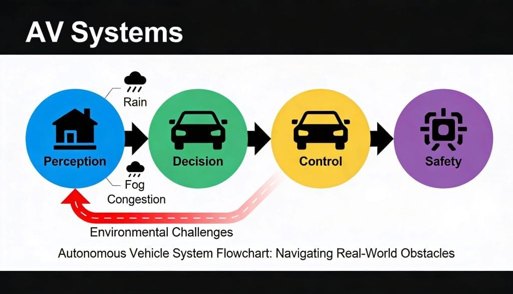
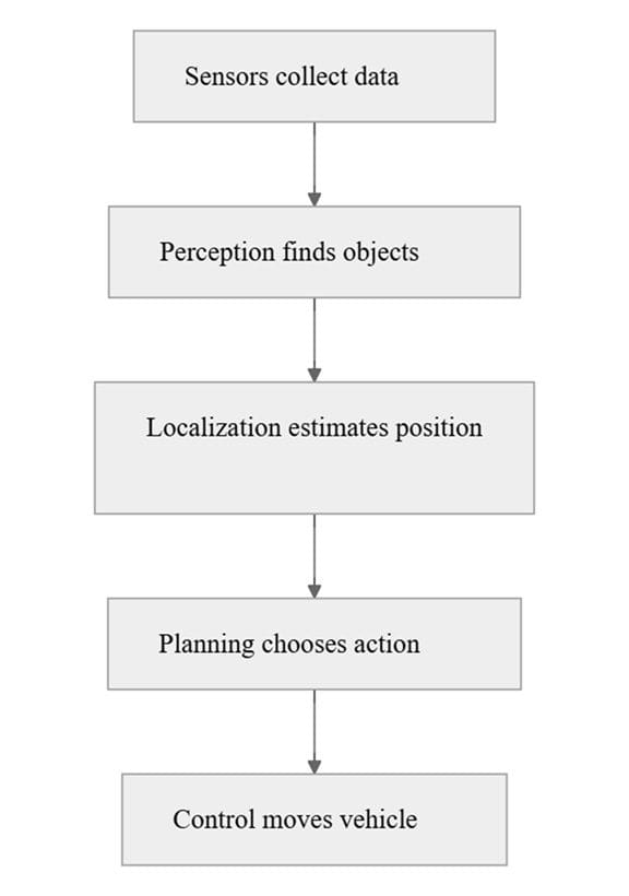
The basic pipeline has four steps. First comes perception. Next comes localization. Then comes planning. Finally, control moves the car (Y. Wang et al., 2024), (Reda et al., 2024a). Each step depends on the last one. If one step fails, safety drops fast. That is why researchers study the full stack. They also test how stages work together (Natan & Miura, 2024).
Perception Systems: How Cars See the Road
Camera vision for lanes, signs, and objects
Perception starts with cameras. Cameras spot lanes, signs, and vehicles. Vision models can also handle multiple tasks (Lee, 2024). One study combined lane segmentation, object detection, and heading estimation (Lee, 2024). Deep learning improves these tasks (Y. Zhao et al., 2024), (Ravali et al., 2025). However, cameras struggle in low light (Carmichael et al., 2024). They also struggle in glare, rain, and fog (Carmichael et al., 2024).
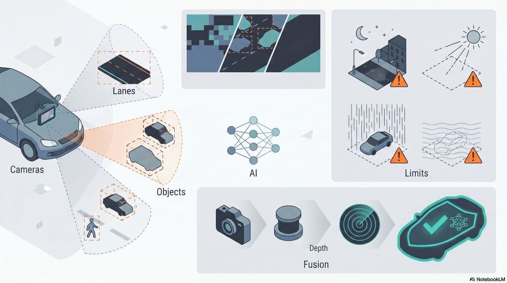
Camera systems work better with depth support. Images show shape poorly. They also miss distance well. That is why researchers add LiDAR and radar (Yang et al., 2025), (Qian et al., 2025). A review says sensor fusion improves robustness (Yang et al., 2025). Another review says fusion helps across cameras, LiDAR, radar, and other sensors (Qian et al., 2025). Fusion also helps under occlusion and dense traffic (Ravali et al., 2025).
LiDAR, radar, and why sensors work together
That leads to LiDAR and radar. LiDAR gives 3D shape data. Radar measures distance and motion well. Sensor fusion can join raw data, features, or decisions (Yang et al., 2025). Some camera-LiDAR systems also reduce wasted computation (Lu et al., 2024), (Wang et al., 2024). Radar adds resilience in harsh scenes. But radar can add noise and ghost targets (Ma et al., 2024). So perception works best when sensors cooperate.
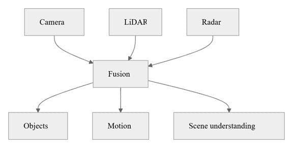
A newer perception trend uses occupancy. Occupancy models map dense 3D space (Xu et al., 2024). They help systems understand where objects may exist (Xu et al., 2024). That makes scene understanding more complete (Xu et al., 2024). In plain terms, occupancy fills the gaps between visible objects. Basically, it helps the car see space, not just objects.
Localization and Mapping: How Cars Know Where They Are
Using maps, GPS limits, and sensor fusion
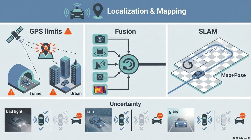
After perception, the car asks where it sits. That is localization. GPS helps, but it has limits. It weakens in tunnels and dense cities (Charroud, El Moutaouakil, Palade, Yahyaouy, et al., 2024), (Zhao et al., 2024). So vehicles combine GPS with other clues (Vraj Mukeshbhai Patel, 2025). Surveys show that localization and mapping support safe driving (Charroud et al., 2024), (Tao et al., 2024). They also support more reliable navigation (Y. Wang et al., 2024).
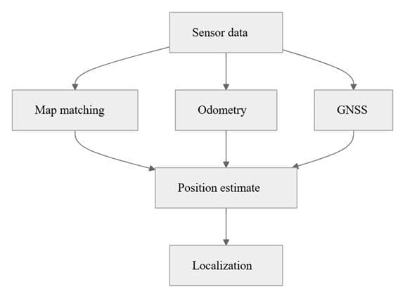
Modern localization uses fusion. LiDAR-IMU-camera systems reduce drift (Zhao et al., 2024). Radar-on-LiDAR methods improve robustness (Ma et al., 2024). One survey notes a shift from GPS-IMU alone toward multimodal systems (Vraj Mukeshbhai Patel, 2025). That shift matters because no single source stays reliable everywhere. The car needs several clues. It then builds a stronger position estimate.
Keeping position accurate in low light and bad weather
Bad weather creates another challenge. Cameras lose detail in darkness and glare (Carmichael et al., 2024). Weather also affects fused systems (Abdulmaksoud & Ahmed, 2025), (Qian et al., 2025). Radar helps in harsh conditions, but it adds noise (Ma et al., 2024). Event and thermal sensors may help when RGB cameras fail (Carmichael et al., 2024). Researchers also test uncertainty methods (Araújo et al., 2024). These methods help the car know when it should slow down.
A useful term here is SLAM. It means simultaneous localization and mapping. The vehicle maps space while tracking itself (Charroud et al., 2024). That helps when maps need updates. It also helps in unfamiliar places. In simple terms, SLAM lets the car build a picture while staying oriented.
Planning and Control: How Cars Choose and Follow a Path
Decision-making for braking, turning, and overtaking
Once the car knows its place, it must choose action. Planning decides braking, turning, and overtaking. Surveys show many planning styles (Hu et al., 2025), (Zhan, 2025). These include rule-based, search-based, and learning-based methods (Hu et al., 2025). Each method has strengths. Rule-based systems stay clear. Learning systems adapt quickly. Search methods explore many options.
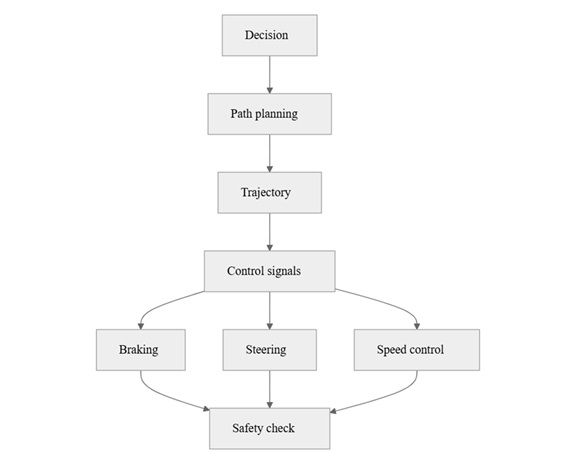
Motion planning, trajectory control, and safety checks
Planning becomes harder at intersections. Other vehicles move unpredictably there (Vinayak et al., 2026). Game-theoretic methods model those interactions (Cai et al., 2024). Reinforcement learning also supports decision-making (Raja et al., 2024), (Yuan et al., 2024). Some work even targets human-like driving behavior (Cai et al., 2025). These studies show one key point. Self-driving cars must think about other road users.
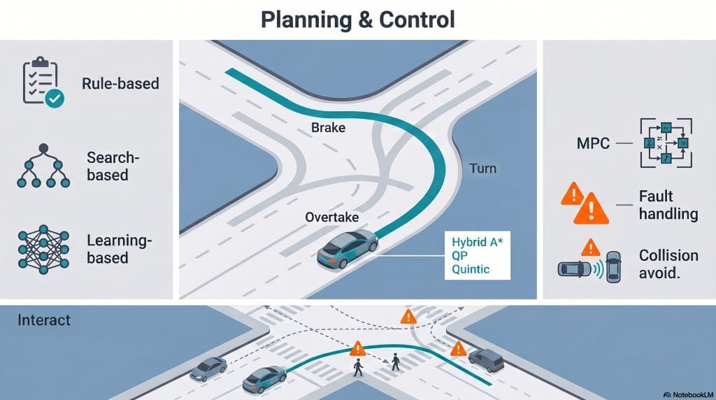
After planning, control moves the car. Control sends steering, braking, and speed commands. Model predictive control appears often in this field (Dong et al., 2024), (Pan et al., 2024), (Li et al., 2024). It plans ahead while respecting limits. That helps with high-speed tracking and lane following (Li et al., 2024). One framework also handles actuator faults and tracking errors (Pan et al., 2024). That matters because roads never stay perfect.
Control also needs safety checks. Many studies focus on collision avoidance (Dong et al., 2024), (W. Lei et al., 2025). Some combine optimization, steering, and braking (Dong et al., 2024). Others use hybrid methods for smoother motion (Jin et al., 2024), (Li et al., 2024), (Wu, 2025). These methods help the car stay steady and avoid obstacles. They also help the vehicle react quickly in traffic.
A strong trajectory matters here. Trajectory planning turns decisions into a drivable path (Li et al., 2024). Some methods use hybrid A* and quadratic programming (Li et al., 2024). Others use quintic polynomials for smooth motion (Jin et al., 2024). Local planners also use Lyapunov ideas to improve efficiency (Arjmandzadeh et al., 2024). The goal stays simple. The car should move safely, smoothly, and on time.
Connectivity, V2V, V2I, and Roadside Support
How vehicle communication expands awareness
Now comes communication. Vehicles can share data with each other. V2V means vehicle-to-vehicle. V2I means vehicle-to-infrastructure. A survey on vehicles-to-everything communication explains this shift (Ušinskis et al., 2024). Cooperative systems can support safer and more efficient driving (Ji et al., 2024). They help vehicles share context beyond onboard sensors.
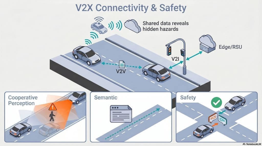
Connectivity can improve perception. V2I systems help at blocked intersections (Mo et al., 2024). Cooperative perception also expands what the car can see (Liu, 2024). V2V-LLM shows that vehicles can share scene understanding and planning cues (Chiu et al., 2025). Another paper uses semantic communication for V2V/V2I cooperation (J.-T. Li et al., 2024). These systems help when sensors miss hidden objects. They also help when roads get crowded.
How connected systems support ethical driving
Communication also supports ethics. One paper argues that V2X can improve ethical driving decisions (Sidorenko et al., 2024). That matters in rare, safety-critical cases (Sidorenko et al., 2024). Better sharing can reduce confusion during complex maneuvers (Sidorenko et al., 2024). So connected driving does more than exchange data. It can also support better choices on the road.
Software-Defined Vehicles: Why Software Matters More Now
How software-defined vehicles change car design
Modern cars are becoming software-defined. That means software controls more vehicle functions. One paper calls this a major architecture shift (Aya et al., 2024). Another explains that SDVs rely on modular software and new control logic (Jiang, 2024). This helps manufacturers update features faster. It also makes cars more flexible over time. In short, software now shapes the car’s behavior more than before.
Security risks in software-defined vehicles
That shift brings security concerns. SDVs increase the attack surface (Khaoula et al., 2025). OTA updates and outsourced apps can create new risks (Khaoula et al., 2025). Another review highlights security and design challenges (Aya et al., 2024). So the car needs safe updates, strong authentication, and resilient architecture. Convenience should never weaken safety.
Legal and Ethical Issues: Who Is Responsible?
Liability after a crash
Autonomous driving also raises liability questions. If a crash happens, who pays? One paper discusses manufacturer, developer, and owner responsibility (Huang, 2025). Another review covers liability, safety, and regulation (Singh et al., 2025). These questions matter because laws often lag behind technology. Clear rules still need to catch up.
Privacy, governance, and public trust
Privacy adds another layer. AVs collect detailed driving data (Kumar, 2024). That data can help safety. It can also expose personal behavior (Boeglin, 2025). One ethical review balances safety and privacy concerns (Kumar, 2024). Another paper discusses freedom and privacy alongside tort liability (Boeglin, 2025). So designers must protect users while improving performance.
Governance also matters. Regulators need safety standards. Designers need accountability. Users need clarity. One review says AV deployment still needs stronger legal frameworks (Singh et al., 2025). Another says legal adaptation remains slow (Huang, 2025). That means autonomous vehicles are not just engineering projects. They are also public policy projects.
Conclusion: What Self-Driving Technology Can Do Next
Main takeaways about sensors, maps, and control
Overall, autonomy depends on integration. Perception reads the road (Y. Wang et al., 2024). Localization finds the car (Vraj Mukeshbhai Patel, 2025). Planning chooses actions (Hu et al., 2025). Control executes them (Pan et al., 2024). Newer systems also use communication and cooperative perception (Ušinskis et al., 2024), (Liu, 2024). Software-defined vehicles then manage more functions through code (Aya et al., 2024).
Future improvements in safety, trust, and everyday use
The big lesson is clear. No single module can do everything. Sensors miss things. Maps drift. Planning faces uncertainty. Yet integrated systems perform better (Ravali et al., 2025), (Araújo et al., 2024). That is why this field keeps growing. Better fusion, safer planning, stronger software, and clearer rules will shape the next generation of driving systems.
Frequently Asked Questions about Autonoumous Vehicles
What does an autonomous vehicle actually do?
It drives with software and sensors. It sees the road, plans movement, and controls the car (Y. Wang et al., 2024).
Why do self-driving cars need many sensors?
Different sensors have different strengths. Fusion helps the car improve perception and reduce blind spots (Yang et al., 2025), (Qian et al., 2025).
Why is localization so hard?
GPS can weaken in tunnels and dense cities (Charroud, El Moutaouakil, Palade, Yahyaouy, et al., 2024), (Zhao et al., 2024). Cars therefore combine maps, LiDAR, cameras, and IMU data (Zhao et al., 2024), (Vraj Mukeshbhai Patel, 2025).
How do V2V and V2I help?
They let vehicles share data with each other and the road (Ušinskis et al., 2024), (Ji et al., 2024). That can improve perception at blocked intersections (Mo et al., 2024).
What makes software-defined vehicles different?
They rely more on software for vehicle functions (Aya et al., 2024), (Jiang, 2024). That makes updates easier, but security more important (Khaoula et al., 2025).
Who is responsible after a crash?
That question still lacks a single answer. Current research points to manufacturers, developers, owners, and regulators (Huang, 2025), (Singh et al., 2025).
References
Arjmandzadeh, Z., Abbasi, M. H., Wang, H., & Zhang, J. (2024). A Lyapunov optimization-based approach to autonomous vehicle local path planning. Sensors, 24(24), 8031. https://doi.org/10.3390/s24248031
Chiu, H.-K., Hachiuma, R., Wang, C.-Y., Smith, S. F., Wang, Y.-C. F., & Chen, M.-H. (2025). V2V-LLM: Vehicle-to-Vehicle cooperative autonomous driving with multimodal large language models. arXiv. https://doi.org/10.48550/arxiv.2502.09980
Huang, H. (2025). Liability allocation in autonomous vehicles: From ethics to law. Interdisciplinary Humanities and Communication Studies, 1. https://doi.org/10.61173/ap42kp92
Ji, Y., Zhou, Z., Yang, Z., Hu, Y.-J., Zhang, Y., Zhang, W., Xiong, L., & Yu, Z. (2024). Toward autonomous vehicles: A survey on cooperative vehicle-infrastructure system. iScience, 27, 109751. https://doi.org/10.1016/j.isci.2024.109751
Li, J.-T., Chen, C.-K., & Ren, H. (2024). Time-optimal trajectory planning and tracking for autonomous vehicles. Sensors, 24(11), 3281. https://doi.org/10.3390/s24113281
Li, C., Liu, H., Jia, Q., Xiong, L., & Wu, H. (2025). Intelligent cooperative perception technology for vehicles and experiments based on V2V/V2I semantic communication. Electronics, 14(24), 4969. https://doi.org/10.3390/electronics14244969
Liu, W. (2024). Situation-aware autonomous driving decision making with cooperative perception on demand. arXiv. https://doi.org/10.48550/arxiv.2409.01504
Natan, O., & Miura, J. (2024). DeepIPC: Deeply integrated perception and control for an autonomous vehicle in real environments. IEEE Access, 12, 49590–49601. https://doi.org/10.1109/ACCESS.2024.3385122
Patel, V. J. (2025). Advancing autonomous vehicle intelligence: An integrated analysis of modern perception and localization systems. International Journal of Scientific Research in Computer Science Engineering and Information Technology, 11, 2377–2385. https://doi.org/10.32628/cseit251112262
Singh, B. P., Ninoria, S. Z., Ahengar, N. A., Gautam, K., Bondwal, P., & Bale, A. S. (2025). Legal and ethical frameworks for AI-driven autonomous vehicles: Navigating liability, safety, and regulatory challenges. Proceedings on Engineering Sciences, 7, 1513–1522. https://doi.org/10.24874/pes07.03.013
- Author
- Latest Posts
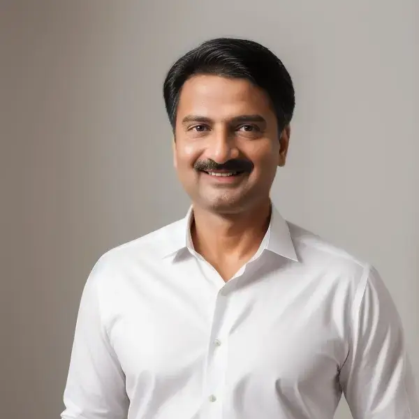
Charudatta Pathak was a student at St. Aloysius High School in Bhusawal, established in 1874, making it one of India’s oldest convent institutions. He earned his bachelor’s degree in mechanical engineering from SSVPS College of Engineering, Dhule in 1995, demonstrating exceptional academic achievement. Thereafter, he launched his career as a CNC programmer in a toolroom. He has utilized FANUC, Deckel, Maho, and Mikron controllers to operate 2-axis and 3-axis machines for the fabrication of jigs, fixtures, dies, and molds. He commenced his career as an academic in 1996, when he assumed the role of lecturer at SSVPS College of Engineering, Dhule. Additionally, he earned his post-graduate degree in CAD/CAM from L. D. College of Engineering, Ahmedabad, in 2000, and then acquired a Ph.D. from COEP in 2011 while concurrently engaged in teaching. Until 2023, he occupied many academic roles, including lecturer, assistant professor, professor, dean, principal, director, and vice chancellor at both public and private universities throughout India. From 2008 to 2010, he served as the project lead in the CAE department of a European multinational firm. During his 28-year professional tenure, he identified a need for dependable books targeted at students in grades 8 to 12, particularly for nascent career planning. He founded ENTECH Digital Magazine, a free monthly publication available on entechonline.com and magzter.com. Teens with a strong interest in Science, Technology, Engineering, and Mathematics (STEM) who aspire to pursue careers in these fields may find ENTECH Digital Magazine beneficial.